Contact : darbyshire.fiona_ann [at] uqam.ca (darbyshire[dot]fiona_ann[at]uqam[dot]ca)
Tél. : 514-987-3000 poste 5054
Fax : 514-987-3635
Geotop-UQAM
201 Avenue Président-Kennedy, 7ème étage
Montréal, QC H2X 3Y7 - Canada
Le ‘laboratoire’ de sismologie comprend un réseau de 17 stations sismographiques de large-bande, situées au centre et nord du Québec, et au Labrador. L’emplacement des sismographes a été développé afin d’être complémentaire aux réseaux sismographiques existants au Canada (stations permanentes du réseau national (RNSC), stations temporaires du projet POLARIS : « Portable Observatories for Lithospheric Analysis and Research Investigating Seismicity »).
Il y a deux cibles principales associées au réseau sismographique :
- La recherche de la structure et la dynamique de la Terre – en particulière, les données des tremblements de terre global peuvent être analysées en plusieurs méthodes pour étudier l’épaisseur et caractéristiques de la croûte, la structure du manteau supérieur et l’anisotropie. Les modèles détaillés résultants seront importants pour mieux comprendre l’assemblage et l’évolution du bouclier canadien.
- Étant donné que les données des stations du réseau sont disponibles à la communauté scientifique en même façon que les données RNSC et POLARIS, l’enregistrement des séismes régionaux seront utile pour les chercheurs qui étudient la distribution d’activité sismique et les risques sismiques dans l’est du Canada.
17 stations sismographiques de type large-bande. Les composantes sont les suivantes :
- Sismomètre – 7 de type Guralp CMG-3ESP avec réponse plate entre 100s période et 50 Hz de fréquence; 10 de type Nanometrics Trillium 120PA avec réponse plate entre 120s période et 50 Hz de fréquence.
- Numériseur – 15 de type Nanometrics Taurus 24-bit digitiser; 2 de type Nanometrics Trident.
- Télémétrie – 15 stations utilisent les connexions standard Internet; 2 utilisent une télémétrie de satellite.
- Alimentation électrique – Une combinaison de stations AC (alimentation électrique standard aux communautés) et DC (alimentation fournie par un ensemble de batteries et panneaux solaires)
| Code | Emplacement | Latitude | Longitude | Élévation (m) | Opération |
|---|---|---|---|---|---|
| BELQ | Belleterre, QC | 47.39801 | -78.68739 | 355 | 2007/08/02 - présent |
| CHGQ | Chibougamau, QC | 49.91050 | -74.37483 | 406 | 2007/10/11 - présent |
| DMCQ | Dolbeau-Mistassini, QC | 48.96455 | -72.06803 | 197 | 2009/09/15 - présent |
| KAJQ | Kangiqsualujjuaq, QC | 58.69405 | -65.93048 | 46 | 2011/08/10 - présent |
| KJKQ | Kuujjuarapik, QC | 55.27687 | -77.74548 | 15 | 2011/08/13 - présent |
| KNGQ | Kangiqsujuaq, QC | 61.58492 | -71.94828 | 54 | 2011/08/05 - présent |
| KRSQ | Kangirsuk, QC | 60.02204 | -69.99115 | 132 | 2011/08/07 - présent |
| LATQ | La Tuque, QC | 47.38355 | -72.78193 | 163 | 2007/09/14 - présent |
| LSQQ | Lebel-sur-Quévillon, QC | 49.05802 | -76.97957 | 308 | 2009/09/13 - présent |
| MATQ | Matagami, QC | 49.75892 | -77.63763 | 280 | 2007/09/19 - présent |
| MKVL | Makkovik, NL | 55.09233 | -59.18405 | 79 | 2011/07/26 - présent |
| NANL | Nain, NL | 56.53712 | -61.68843 | 34 | 2011/07/24 - présent |
| NEMQ | Nemaska, QC | 51.68370 | -76.25757 | 197 | 2007/08/27 – 2009/09/10 |
| NMSQ | Némiscau, QC | 51.71328 | -76.02372 | 275 | 2009/09/12 - présent |
| NWRL | North West River, NL | 53.52526 | -60.14245 | 6 | 2011/07/21 - présent |
| WBHL | Wabush, NL | 52.90296 | -66.86634 | 595 | 2011/07/18 - présent |
| WEMQ | Wemindji, QC | 53.05350 | -77.97370 | 172 | 2005/06/23 - présent |
| YOSQ | Près de la Mine Renard, QC | 52.86657 | -72.19983 | 649 | 2005/06/26 - présent |
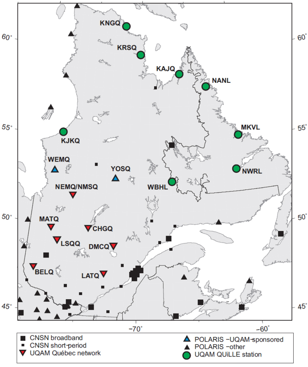
Carte des stations sismographiques (UQAM et autres) en opération dans la région.
Toutes les données du réseau sismographique UQAM sont disponibles à partir des archives du centre national de données canadiennes (CNDC) de Ressources Naturelles Canada. Pour toute information concernant les réseaux canadiens et de l’acquisition des données, consultez les liens sur le site Web seismescanada.rncan.gc.ca/index-fra.php