Contact : darbyshire.fiona_ann [at] uqam.ca (darbyshire[dot]fiona_ann[at]uqam[dot]ca)
Tél. : 514-987-3000 poste 5054
Fax : 514-987-3635
Geotop-UQAM
201 Avenue Président-Kennedy, 7ème étage
Montréal, QC H2X 3Y7 - Canada
The seismology ‘laboratory’ consists of 17 broadband seismograph stations, situated in central and northern Québec and Labrador. The station locations in the network have been chosen to complement the coverage from existing networks in Canada (permanent stations of the Canadian National Seismograph Network (CNSN) and temporary stations associated with the POLARIS project : ‘Portable Observatories for Lithospheric Analysis and Research Investigating Seismicity’).
The seismograph network targets research in the following disciplines:
- Earth structure and dynamics – data from global earthquakes can be analysed using several different methods to study the thickness and properties of the crust, the structure of the upper mantle, and regional seismic anisotropy. Detailed models of this type are fundamental for a better understanding of the processes of assembly and evolution of the Canadian Shield.
- The data from the network are available to the scientific community along with CNSN and POLARIS data. Detection of regional earthquakes by the network will be useful for researchers investigating the distribution of seismic activity and seismic hazard across eastern Canada.
17 broadband seismograph stations, with the following components:
- Seismometer – 7 Guralp CMG-3ESP with response flat to velocity from 100s period to 50 Hz frequency; 10 Nanometrics Trillium 120PA with response flat to velocity from 120s period to 50 Hz frequency.
- Digitiser – 15 Nanometrics Taurus 24-bit digitisers; 2 Nanometrics Trident
- Telemetry – 15 stations use standard Internet connections; 2 use satellite telemetry
- Power supply – A combination of AC stations, using standard AC power at communities, and DC stations, which are self-sufficient, using batteries and solar panels for power.
| Code | Location | Latitude | Longitude | Elevation (m) | Operation |
|---|---|---|---|---|---|
| BELQ | Belleterre, QC | 47.39801 | -78.68739 | 355 | 2007/08/02 - présent |
| CHGQ | Chibougamau, QC | 49.91050 | -74.37483 | 406 | 2007/10/11 - présent |
| DMCQ | Dolbeau-Mistassini, QC | 48.96455 | -72.06803 | 197 | 2009/09/15 - présent |
| KAJQ | Kangiqsualujjuaq, QC | 58.69405 | -65.93048 | 46 | 2011/08/10 - présent |
| KJKQ | Kuujjuarapik, QC | 55.27687 | -77.74548 | 15 | 2011/08/13 - présent |
| KNGQ | Kangiqsujuaq, QC | 61.58492 | -71.94828 | 54 | 2011/08/05 - présent |
| KRSQ | Kangirsuk, QC | 60.02204 | -69.99115 | 132 | 2011/08/07 - présent |
| LATQ | La Tuque, QC | 47.38355 | -72.78193 | 163 | 2007/09/14 - présent |
| LSQQ | Lebel-sur-Quévillon, QC | 49.05802 | -76.97957 | 308 | 2009/09/13 - présent |
| MATQ | Matagami, QC | 49.75892 | -77.63763 | 280 | 2007/09/19 - présent |
| MKVL | Makkovik, NL | 55.09233 | -59.18405 | 79 | 2011/07/26 - présent |
| NANL | Nain, NL | 56.53712 | -61.68843 | 34 | 2011/07/24 - présent |
| NEMQ | Nemaska, QC | 51.68370 | -76.25757 | 197 | 2007/08/27 – 2009/09/10 |
| NMSQ | Némiscau, QC | 51.71328 | -76.02372 | 275 | 2009/09/12 - présent |
| NWRL | North West River, NL | 53.52526 | -60.14245 | 6 | 2011/07/21 - présent |
| WBHL | Wabush, NL | 52.90296 | -66.86634 | 595 | 2011/07/18 - présent |
| WEMQ | Wemindji, QC | 53.05350 | -77.97370 | 172 | 2005/06/23 - présent |
| YOSQ | Near Renard Mine, QC | 52.86657 | -72.19983 | 649 | 2005/06/26 - présent |
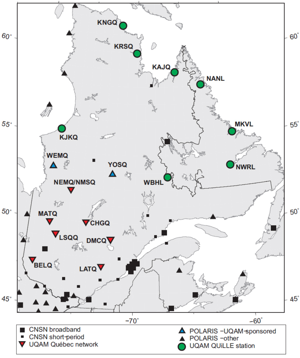
Map of UQAM seismograph stations and others in operation across the region.
All the data from the UQAM seismograph network are available from the archives of the Canadian National Data Centre (CNDC), Natural Resources Canada. For all information about the Canadian networks, and data acquisition, follow the links on the website http://earthquakescanada.nrcan.gc.ca/index-eng.php